3720 Butner Road
City of South Fulton, Fulton County, Georgia
A 3.8-acre residential development opportunity with a clear path to eight single-family homes. Full zoning analysis, FEMA flood zone strategy, and conceptual site plan included.
Total Land Area
Proposed Development
Per Home
Proposed District
3.8 Acres of Opportunity in South Fulton
This property represents a rare chance to develop a private family compound or small residential subdivision in the growing City of South Fulton. The land has never flooded since its acquisition in 2019, and a clear legal pathway exists to resolve the FEMA flood zone designation that has previously blocked development.
With the right zoning reclassification and a FEMA Letter of Map Amendment, this parcel can support eight 2,500-square-foot single-family homes — an ideal configuration for a family compound or a small-scale residential development.
Property Details
Located in the Cliftondale Community
The property lies within the Cliftondale Overlay District, but single-family detached homes are expressly exempt from overlay design requirements.
What Can Be Built on This Land
A rezoning from R-1 to R-4 is the key step that unlocks the full development potential of this 3.8-acre parcel.
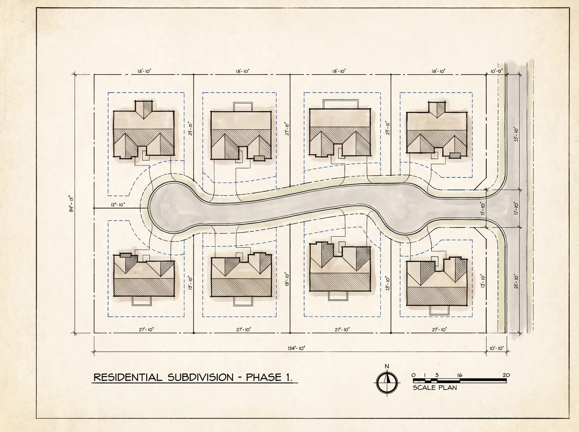
Conceptual subdivision layout — 8 homes on 3.8 acres
Cliftondale Overlay District — Exempt
Per Article XII-L, Section 12L.2 of the Fulton County Zoning Resolution, the Cliftondale Overlay District expressly excludes "single family detached dwelling units" from all overlay design requirements. Your proposed development is fully exempt.
Subdivision Required
Section 402.05 of the Zoning Ordinance limits each lot to one principal building. To build eight homes, the parcel must be legally subdivided into eight separate lots before building permits can be issued.
R-4 Single-Family (Recommended)
RecommendedThe optimal district for your goal. Allows up to 18 lots on 3.8 acres, comfortably accommodating 8 homes with generous lot sizes.
Rezoning Process Overview
- 1.Hire a local land use attorney or planning consultant
- 2.Submit rezoning application to City of South Fulton Planning Dept.
- 3.Attend public hearing before the Planning Commission
- 4.City Council vote on rezoning ordinance
- 5.Upon approval, submit subdivision plat for review
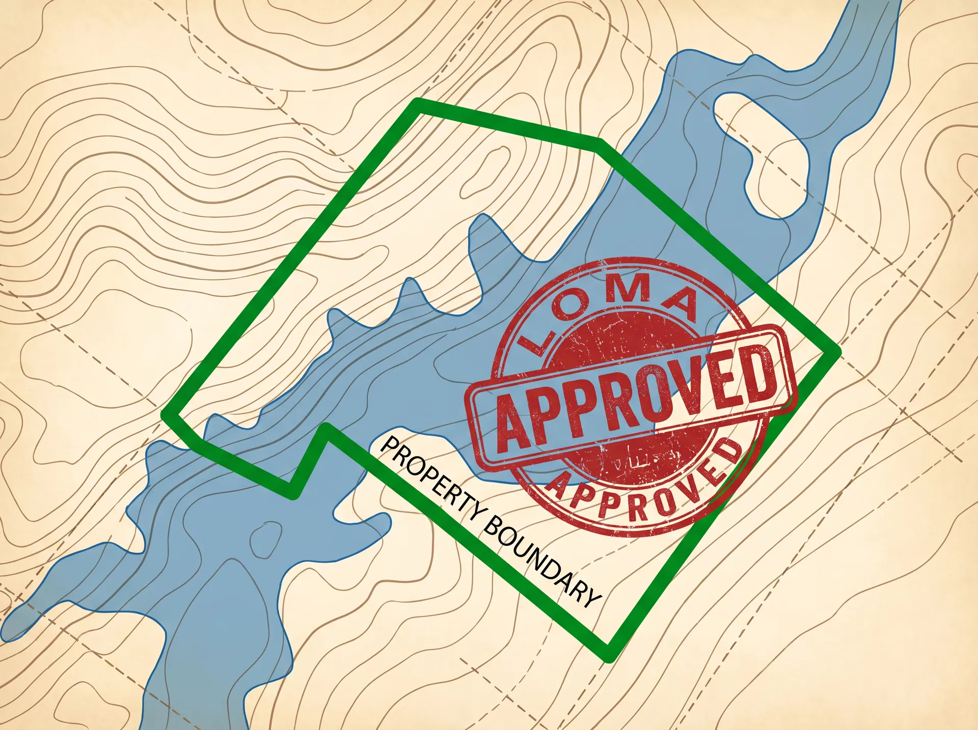
Removing the Flood Zone Designation
The property is currently mapped in FEMA Zone AE (100-year flood zone) on FIRM Panel 13121C0341F. However, because the land has never flooded since 2019, there is strong reason to believe the natural ground elevation is above the Base Flood Elevation — making it eligible for a Letter of Map Amendment (LOMA).
Current Flood Zone Facts
If Fill is Required: LOMR-F
If the survey reveals that any portion of the land is below the BFE, engineered fill can be placed to raise building pads. A Letter of Map Revision Based on Fill (LOMR-F) would then be filed. This process is more complex but remains a viable path.
The LOMA Process — Step by Step
Commission a Topographic Survey
Hire a Licensed Land Surveyor (LLS) or Registered Professional Engineer (PE) in Georgia. They will conduct a precise topographic survey to determine the Lowest Adjacent Grade (LAG) and lowest lot elevation across the entire 3.8-acre parcel.
Obtain an Elevation Certificate
The surveyor will compare your property's lowest ground elevation to the Base Flood Elevation (BFE) shown on FEMA FIRM Panel 13121C0341F. If your land is at or above the BFE, they will complete a FEMA Elevation Certificate documenting this fact.
Submit the LOMA Application to FEMA
Using the MT-EZ form or FEMA's Online Letter of Map Change (LOMC) portal, submit the application along with the Elevation Certificate, property deed, and a copy of the FIRM panel. FEMA does not charge a fee for LOMA review.
FEMA Review and Determination
FEMA reviews the application and issues a formal determination. If approved, the LOMA officially removes the property from the Special Flood Hazard Area (Zone AE), satisfying the City of South Fulton's subdivision approval requirements.
Once the LOMA is Approved
The LOMA officially removes the property from FEMA Zone AE. This satisfies the City of South Fulton's requirement under Section 402.02 of the Zoning Ordinance, which mandates that all buildable lot areas be located outside a floodplain before subdivision approval. Flood insurance will no longer be mandatory for mortgage lenders, making the property significantly more attractive to buyers and lenders alike.
Eight Homes on 3.8 Acres
The layout below shows how eight 3BR/2BA homes can be arranged across the property while meeting all R-4 setback requirements.
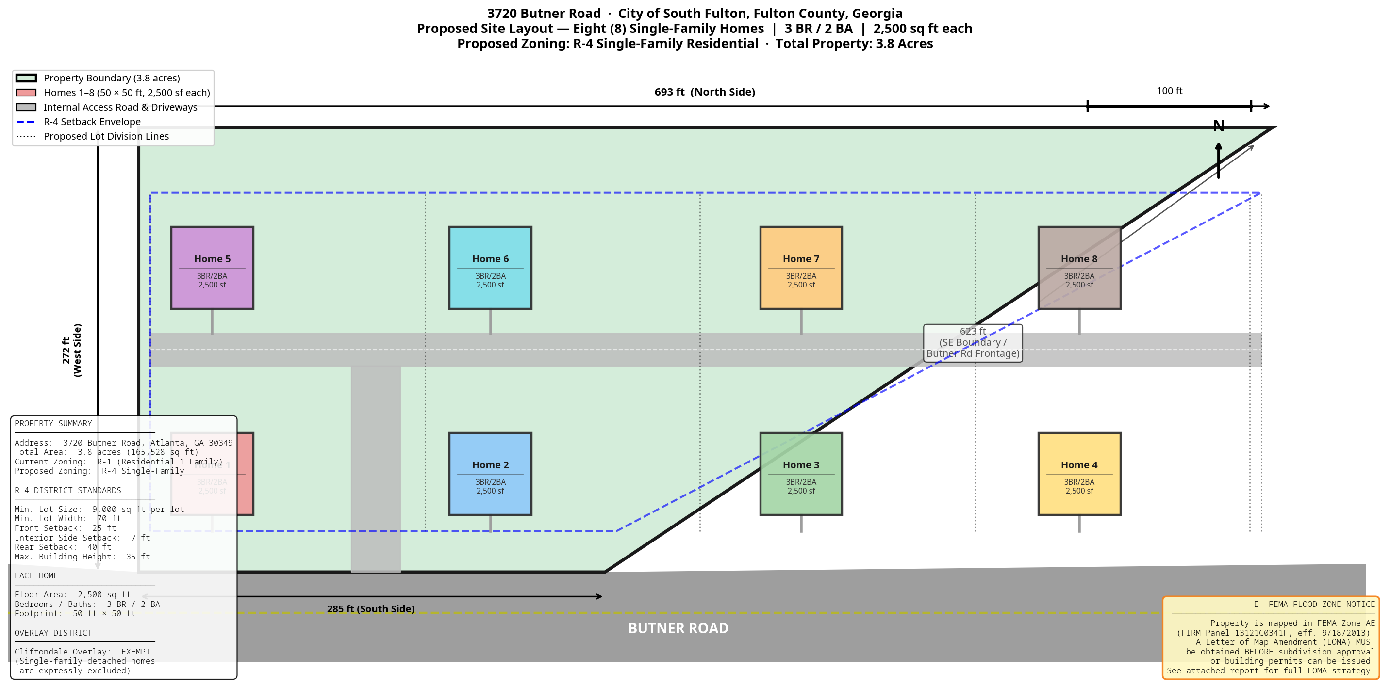
Conceptual site plan drawn to scale. North side: 693 ft · West side: 272 ft · South side: 285 ft · SE boundary: 623 ft
Each Home: 3 BR / 2 BA / 2,500 sq ft
R-4 Setback Requirements
Lot Area Calculation
Each proposed lot exceeds the R-4 minimum by more than double, providing generous spacing between homes and ample yard area for families.
Next Steps to Unlock Development
The path from the current state to a fully permitted eight-home subdivision is clear and achievable. The following steps outline the recommended sequence of actions.
Commission a Topographic Survey
Hire a licensed Georgia surveyor to determine the property's ground elevations relative to the FEMA Base Flood Elevation. This is the foundational step that unlocks everything else.
File the LOMA Application with FEMA
Once the Elevation Certificate confirms favorable elevations, submit the LOMA application via FEMA's Online LOMC portal. No fee is required. FEMA typically responds within 45–60 days.
Apply for Rezoning to R-4
Engage a local land use attorney or planning consultant to prepare and submit a rezoning application to the City of South Fulton Planning Department. This can proceed concurrently with the LOMA process.
Submit Subdivision Plat
Once both the LOMA and rezoning are approved, submit a preliminary subdivision plat based on the conceptual site plan. This divides the 3.8 acres into eight individual lots, each eligible for a building permit.
Ready to Explore This Opportunity?
This analysis demonstrates a clear, actionable path to developing eight single-family homes on this 3.8-acre parcel. The LOMA process is straightforward, the rezoning is supported by the parcel's size and location, and the conceptual site plan confirms the feasibility of the development vision.
Property Contact
This analysis is based on a review of the City of South Fulton Zoning Ordinance, the Cliftondale Overlay District regulations, and FEMA FIRM Panel 13121C0341F. It is provided for informational purposes only and does not constitute legal, engineering, or professional planning advice. Consult a licensed attorney, surveyor, and land use planner before making development decisions.